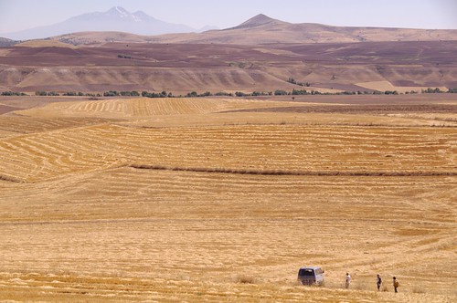
Low-relief erosional surfaces are widely present in central Anatolian highland, where mountains or hills surrounded by gentle slopes are covered with crop fields to their summits. Slopes on these "low-relief" surfaces are generally gentle and geomorphic processes therein seems relatively slow, but many active geomorphic features are actually found: for instance, current small rivers incises for several meters in depth into a wide Holocene floodplain (shown in the center of the photo, a river runs along the trees from left to right), and steep slopes beyond the river have thin soil layer and surface materials are actively transported during heavy rainfall and in snowmelt season. Although the overall form of the low-relief surfaces can be peneplain or a relict landform of ancient long-term erosion, present geomorphic process are not so inactive in the region.
Many active faults run through these low-relief surfaces surrounding the Anatolian highland. A pull-apart basin, divided by normal or slip faults (a part of the East Anatolian fault zone), is located beyond the hill ridge in the upper portion of the photo, where volcanic activities have occurred since several million years ago.
Mt. Erciyes (3,917 m), shown in the upper left of the photo, is the highest volcano in central Anatolia. The mountain provides a place of skiing in winter, and snow around the summit is observable year-round. A glacier is present just below the summit on the north-facing slope (photo), which have severely retreated and is shortly disappearing. The photo shows an amazing scenery which contrast strong sunlight in the close view and cold ice in the distant view.
(Photograph and text by Yuichi S. Hayakawa, Aug. 2009)
アナトリア高原中央部は広く侵食小起伏面からなる。乾燥して高木の乏しいなだらかな山には,その頂上にまで畑が広く覆っている。山や丘のてっぺんには,テペと呼ばれる遺丘が多く乗り,写真もそのうちの一つから撮影したものだ。
「小起伏」面とはいっても,しかし,それなりに起伏はある。道には坂やコーナーが延々と続き,大河川は深い谷を刻む。写真中央遠方の緑の木々に沿っては小川が流れており,数百m幅の広い沖積層を谷底に溜める。その向こうの急斜面は草もまばらで土壌も浅く,豪雨や雪解け時には土砂移動が生じている。小起伏面の概形は,かつての河川等による侵食を反映した残存地形(いわゆる準平原)であると言われる。しかし,現在でもさまざまな地形変化プロセスが,速度は遅くとも,着実に進行していることも事実である。
こうした小起伏面を切り裂く断層帯が,アナトリア小プレートを取り囲むように分布している。写真上,稜線の向こう側には,南西―北東に走る正・横ずれ断層帯に挟まれた盆地が広がる。この地域はテクトニクス的な拡大場にあり,火山活動が数百万年以上も前から続いている。
左に遠望されるのがエルジエス火山(標高3,917 m)。中央アナトリア地方の最高峰である。冬にはスキーリゾートとして賑わい,夏でも山頂付近には雪が残る。写真手前が北向き斜面であり,山頂直下には氷河や岩石氷河も存在する。ただ,この氷河も縮小傾向にあり,一昨年と昨年は史上初めて麓からの遠景で夏に雪が見えなくなったという。なお,奇岩地形で有名なカッパドキアはこの火山の西に広がり,これはエルジエスより古い時代の火山活動にともなう火砕流堆積物の台地が開析されてできている。
(2009年8月撮影)

0 件のコメント:
コメントを投稿