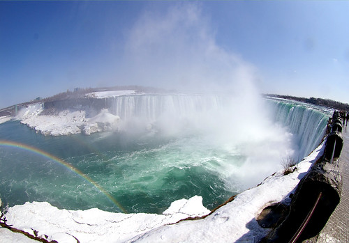
Niagara Falls was formed at the Niagara Escarpment, 11 km downstream the present location of the waterfall, on ca. 12,500 years ago when the Niagara River drained from upstream Lake Erie across the cliff. The mean recession rate is ca. 1 m/y, while the long-term recession rate has varied due to changes of water discharge of the Niagara River. Water intake for power plant since a century ago caused decrease of the water discharge flowing over the waterfall, and the waterfall erosion has been stagnated, with its present recession rate on the order of centimeters a year. The embowed horseshoe shape of the waterfall can also be another factor stabilizing the waterfall against erosion.
An erosion model on Niagara Falls has been proposed by G.K. Gilbert a century ago, suggesting the caprock structure of the waterfall face, in which erosion dominates on the lower shale layer (undercut by plunge-pool swirling flow). Although the model has long been regarded as representative one that explains waterfall erosion, such a caprock model cannot be applied for many other waterfalls that are buttressed, and severe erosion in the plunge pool is also doubtful because currents in the deep pool may not be so strong to cause entrainment of fallen brocks and bedrock erosion.
Photo and text by Yuichi S. Hayakawa
ナイアガラフォールズは約12,500 年前,ローレンタイド氷床の後退にともない,エリー湖からオンタリオ湖へ向けて北流したナイアガラ川が,東西に走るナイアガラ・エスカープメントを横切る地点で形成された。以降,継続的な侵食により滝は現在の位置まで約11 kmを後退した。平均して年間約1 m 弱の後退速度となるが,過去の後退速度は一定ではなく,たとえば約1万年前からの5000年間は,エリー湖より上流の氷河湖からの流出経路が異なったため,1 kmしか後退が進まなかったことが貝化石の14C 年代(未較正)から推定されている。また,20 世紀には水力発電のための取水が始まり,観光用に日中の流量は確保されているものの,滝を通過する総流量は激減した。同時に滝の侵食も遅くなり,現在の後退速度は年間数 cm 程度であると言われている。また,ホースシューフォールズ(写真手前)は300 年前にはより直線的な平面形状を呈していたが,これが徐々に馬蹄形となることで応力分散により安定し,侵食が遅くなる一因となっているという説もある。
20世紀初頭に提案されたG.K. Gilbert によるナイアガラフォールズの侵食モデルは,滝壺の渦流が滝面下部の頁岩の水平層を侵食し,キャップロックとなる上部のドロマイトが崩落する,というものであった。長い間これが滝の侵食の典型的なモデルとして広まっていたが,実際にはキャップロック構造をもたない滝は多く,滝一般においての事例としてはむしろ稀な方であろう。さらに滝壺底部に侵食をもたらすほどの渦流が生じるという説明は,ナイアガラフォールズにおいてさえ推測の域を出ておらず,滝の侵食プロセスに関して不明な点は未だに多い。

(表紙写真:地形 29-2, 2008)