2013/10/20

伊豆大島西部の斜面崩壊空中写真 / Orthorectified airphotos of slope failure in the western Izu-Oshima Island

2013年10月16日、台風26号の豪雨で発生した伊豆大島西部の斜面崩壊。
国土地理院の電子国土Web.NEXT(試験公開)で空中写真が公開されている。
このうちいくつかの垂直写真(10/17撮影)から、オルソ補正写真を作成し、崩壊の発生前後の比較をしてみた。
(位置補正は水平数メートル程度?で大雑把。)
Google Earth で閲覧するためのKMLはこちら→ KMZファイル (約71MB)
サイドバーにあるレイヤの透明度調整バーで、前後の比較が可能。


もともとあった谷部の植生の色が微妙に違っていたり、小さな崩壊の履歴はあったのかもしれない。

2013/03/21

Large boulders and pedestals on uplifted coastal terraces in Kikai Island, southwestern Japan / 喜界島,海岸段丘面上の巨礫と台座岩


Large boulders and pedestals on uplifted coastal terraces in Kikai Island, southwestern Japan / 喜界島,海岸段丘面上の巨礫と台座岩

   Kikai Island (Kikaijima) is famous for the modern coral reef studies undersea. However, the ancient coral reef, which currently composes coastal rocky landforms, is also another important topic for geomorphologists.
   Numerous large limestone boulders, coming either from ocean as tsunami deposits or from mountain-side cliffs as fallen block, are distributed upon the coral-limestone surface of uplifted coastal terraces in eastern Kikai Island. Being fixed on the uplifted surface, the boulders act as "umbrella" to save the bedrock limestone beneath them from dissolution by raindrop. The surface of the terraces broadly lowers due to the rainfall-induced dissolution, and the protected portions beneath the boulders remains as pedestal.
   The boulders in the picture are located on relatively young surface of uplifted coastal terrace, whose duration of dissolution is approximately 1,500 years. Small pedestals with a height of several tens of centimeters, as well as dissolution pits on the surrounding terrace surface, are being formed . Higher pedestals, often exceeds 1 m at 6,000 years after emergence, are observed on higher terraces inland. The pedestals therefore allow us to obtain the surface lowering rate of the uplifted coastal terraces, which means the dissolution rate of the coral-reef limestone in Kikai Island. (See also the report by Hayakawa et al. in thisissue)


 サンゴ礁石灰岩からなる喜界島の完新世海成段丘面上には,同じくサンゴ礁石灰岩からなる巨礫が多く転がっている。津波で打ち上げられたか,あるいは陸側の段丘崖から落ちてきたか――いずれにせよ,定置かつ離水してから後,巨礫は「傘」となって,直下の基盤岩に雨滴との接触の機会を失わせる。一方,雨に晒された周りの地表面は次第に溶解し,その高度を減じていく。雨宿りの結果取り残された基盤岩は,巨礫を支える台座岩(ペデスタル)として現前する。
 写真は喜界島東岸の比較的新しい離水面に載る巨礫で,台座岩の形成が始まってから約1500年とまだ時間が浅い。そのため「台座」と呼ぶには未熟かもしれないが,周辺の溶食凹地とともに,巨礫の下部には数10 cm程度の台座岩が形成されつつあるのが見える。陸側の,より高く隆起した段丘面では,古いものほど台座岩は高く,たとえば6000年前の離水面でのそれは2 m近くにも及ぶ。喜界島における地表面の低下速度,すなわち石灰岩の溶解速度は,こうした台座岩の高さとその溶解継続時間とから求めることができる。
 なお,撮影地の背後には,サンゴの石垣で有名な阿伝集落がある。また,一段高い段丘面に載る別の巨礫と台座岩がある末吉神社も近い(本号掲載論文参照)。(2009年1月撮影)


(表紙写真:地形30 (3), 2009) 

Large boulders and pedestals on uplifted coastal terraces in Kikai Island, southwestern Japan / 喜界島,海岸段丘面上の巨礫と台座岩
(百之台から撮影地近辺を望む)


2013/01/30

Uplifted shore platform and cyclone-derived debris flow deposits, northeastern coast of the Arabian Peninsula, Sultanate of Oman / アラビア半島北東海岸(オマーン国)の隆起ベンチとサイクロンによる砂礫堆積物

Uplifted shore platform and cyclone-derived debris flow deposits, northeastern coast of the Arabian Peninsula, Sultanate of Oman / アラビア半島北東海岸(オマーン国)の隆起ベンチとサイクロンによる砂礫堆積物
Location: Uplifted shore platform and cyclone-derived debris flow deposits, northeastern coast of the Arabian Peninsula, Sultanate of Oman / アラビア半島北東海岸(オマーン国)の隆起ベンチとサイクロンによる砂礫堆積物

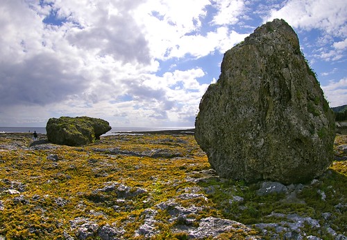
   On June 6, 2007, a gigantic cyclone “Gonu” attacked eastern Oman, the northeastern Arabian Peninsula. The cyclone attack caused flash floods in wadi channels in the dry region, entraining vast amount of sand and gravel which instantaneously traveled throughout the channels. Coastal deposits of the sand and gravel spread around the wadi outlets (left side in the photo), and such numerous gravels associated with repeated storms might have been trapped into coral reefs to form gravel-rich carbonate rocks (or, calcareous conglomerate) shown in the bottom of the photo. The uplifted shore platform has a 3-m height at its edge with sharp and deep notches, and partially with fallen blocks induced by wave and gravity forces (right-top in the photo), which are rapidly broken toward small pieces. A shell midden site (BIMMA-1) at the Neolithic to Bronze Age is on the uplifted platform. The platform cliff, as well as the midden itself, has therefore suffered from erosion for thousands of years. Together with this uplifted shore platform, several coastal terraces with heights of 100 to 500 m are formed in the backyard, indicating the active tectonics in this region. Furthermore, the Oman ophiolite, the largest, most famous and complete ophiolite in the world, forms high mountains with altitudes of 2,000–3,000 m in the inland areas along the coast.

 2007年6月6日,アラビア海(インド洋)で発生した大型サイクロン「ゴヌ」が北上を続け,オマーン湾とその周辺諸国を襲った。観測史上最大級のこのサイクロンは,オマーンの乾燥した大地に強風と豪雨をもたらし,普段は水の枯れたワディにも大量の水が流れ込んだ。激流は河床に溜まっていた砂礫を巻き込み,河口まで一気に運び出す。表紙写真の左側にみえる堆積物は,その際にワディから運び出された砂礫堆である。足元のサンゴを含む石灰岩にも礫が多く混入しており,この場所で大量の砂礫が繰り返し供給されていることを示している。右側と手前に張り出しているのは,高さ約3 m の隆起ベンチである。海側小崖の基部には鋭いノッチが発達し,写真右側の奥には波と重力とに耐えきれず崩落したブロックもみられる。この隆起ベンチ上には新石器後半から青銅器時代(およそ4-6千年前)の貝塚が分布し,少なくとも数千年間,ベンチの端は波の侵食を受けている。一度崩落したブロックは波の作用により急速に解体され,隆起ベンチ上には細かく打ち砕かれたブロックの破片が散在している。この写真の背後には数段の海岸段丘(標高100-500 m)が発達し,アラビア海沿岸域における地殻変動の歴史を物語っている。より内陸側には,かつてのテチス海の海洋地殻が標高2,000-3,000 m級の山脈を形成するほど持ちあげられ,世界で最も大規模かつ完全なオフィオライト,オマーンオフィオライトとして広く分布している。(2008年3月撮影)

(表紙写真:地形30 (2), 2009