2015/06/05

Bedrock erosion by waterfall recession after the 921 Chi-Chi earthquake, central Taiwan / 台湾中部,九二一地震で生じた滝の後退による岩盤侵食

Bedrock erosion by waterfall recession after the 921 Chi-Chi earthquake, central Taiwan / 台湾中部,九二一地震で生じた滝の後退による岩盤侵食

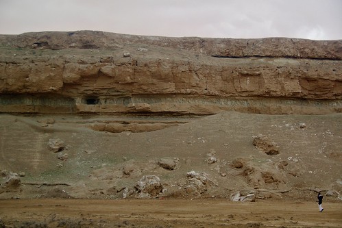
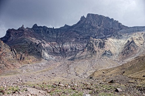
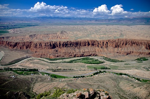
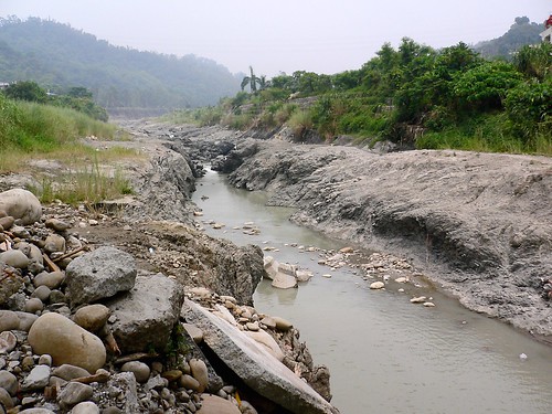
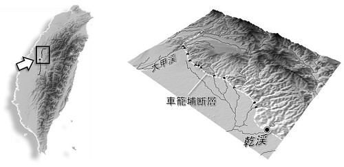
   The Chi-Chi earthquake (M7.7), occurred on September 21, 1999, was associated with the activity of the Chelungpu Fault, along which surface ruptures continues for ca. 100 km with up to 10 m of vertical displacement. Waterfalls were formed in rivers flowing over the ruptures, and the most famous one having a height of 7 m was appeared in the Tachia River at the northernmost portion of the fault. The picture shows a fault-induced waterfall with 4-m height (at the center, slightly seen as white color) and a gorge of inner channel downstream of the waterfall in the Gan River in July 2005. This waterfall has receded for more than 200 m from the original location in 6 years after the earthquake, where rapid waterfall recession can be caused by abundant gravels transported from upstream areas with harder rocks, acting as abrasion material. We can also observe sidewall notches and downstream widening of the gorge, which suggest lateral erosion by the river following the waterfall recession. On the right side of the Gan River, facilities of formerly an elementary school, located just on the fault rupture and broken by the earthquake, are preserved and on exhibit as the Earthquake Museum.
(July 26, 2005, photo and text by Yuichi S. Hayakawa)

 1999年9月21日,台湾中部でM7.7 の大地震が発生した。この際活動した車籠埔断層に沿って,地表には約100 km に渡る地震断層が生じ,その鉛直変位量は最大で10 m に及んだ。断層が河川を横切る地点は滝となり,とくに断層北部の大甲渓で高さ7 mの滝が形成されたことは多く報じられた。写真は,断層を跨ぐ河川の一つである乾渓において,2005年7月に撮影されたものである。細長く続く峡谷(inner channel)の奥に高さ約4 m の滝があり,この滝は地震発生から6年の間に元の断層の位置から200 m 以上も後退した。年間で数十メートルという後退速度は,岩盤侵食速度としては極端に大きい。これは,風化に対して脆弱な泥質の岩盤であることに加え,上流域から運搬されてくる硬質な砂礫が摩耗剤としてはたらき,侵食作用を促進させていることが一因であると考えられている。また,峡谷は下流ほど幅が広がり,その側壁にはノッチが形成されており,滝が後退したあとの側刻作用による谷の拡幅を示している。この乾渓右岸,断層の真上にあった学校は,その倒壊した建物や盛り上がった校庭が,地震教育園として保存・公開されている。
解説・写真:早川裕一

Untitled

(表紙写真:地形29-1, 2008

2015/04/08

Cliff of fluvial terrace along the Euphrates River near Ar-Raqqa, Syrian Arab Republic / シリア共和国ラッカ近郊、ユーフラテス川右岸の河岸段丘崖

Cliff of fluvial terrace along the Euphrates River near Ar-Raqqa, Syrian Arab Republic / シリア共和国ラッカ近郊、ユーフラテス川右岸の河岸段丘崖

(March 7, 2010, photo by Yuichi S. Hayakawa)

 ビシュリの台地の北縁は、ユーフラテス川により切り込まれ比高60 m ほどの段丘崖をなす。崖は中新統の石灰岩・石膏岩と挟在するシルト質泥岩からなるが、1974年のタブカダム建設以降ユーフラテスの氾濫は抑えられ、現状、崖が侵食されることはほとんどない。

(表紙写真:地形32-3, 2011

2015/04/07

Erosional landforms of layered, non-welded ignimbrites in Cappadocia, Turkey / トルコ共和国、カッパドキアにおける火砕流堆積物の侵食地形

Erosional landforms of layered, non-welded ignimbrites in Cappadocia, Turkey / トルコ共和国、カッパドキアにおける火砕流堆積物の侵食地形 

 The rock mound on the right side is an inserberg named Uçhisar, in which many artificial caves are formed. Visited during the field trip of JGU-Ankara University joint meeting.
(September 16, 2010, photo by Yuichi S. Hayakawa)

 非溶結の火砕流堆積物が風化・侵食を受け、奇岩地形が広がっている。右側の岩山はウチヒサルと呼ばれる残丘地形。多くの洞穴が掘られている。JGU合同大会(アンカラ大学との共催)の巡検で訪れた。

(表紙写真:地形32-2, 2011

2015/04/06

Deeply dissected valley in an alluvial fan of the Tovus River, western Azerbaijan / アゼルバイジャン共和国西部、トヴス川扇状地の開析谷

Deeply dissected valley in an alluvial fan of the Tovus River, western Azerbaijan / アゼルバイジャン共和国西部、トヴス川扇状地の開析谷

July 25, 2012, photo by Yuichi S. Hayakawa

 小コーカサス山脈から北流(写真左から右)するトヴス川は、本流であるクラ川に注ぐところで北向きの扇状地を形成する。その開析谷の比高は写真の地点で約60 m に及び、谷の内部には後氷期に形成された数段の段丘がみられる。現河床からは礫の採取も活発に行われ、対岸ではその工場からの煙が立ち上がっている。扇状地上を東西に流れる灌漑用水は、径2 m 超のパイプを通り、サイフォンとしてトヴスの深い谷を横断する。

(表紙写真:地形34-1, 2013

2015/02/03

Erosion of Niagara Falls, Canada and the USA / ナイアガラフォールズの侵食

Erosion of Niagara Falls, Canada and the USA / ナイアガラフォールズの侵食

   Niagara Falls was formed at the Niagara Escarpment, 11 km downstream the present location of the waterfall, on ca. 12,500 years ago when the Niagara River drained from upstream Lake Erie across the cliff. The mean recession rate is ca. 1 m/y, while the long-term recession rate has varied due to changes of water discharge of the Niagara River. Water intake for power plant since a century ago caused decrease of the water discharge flowing over the waterfall, and the waterfall erosion has been stagnated, with its present recession rate on the order of centimeters a year. The embowed horseshoe shape of the waterfall can also be another factor stabilizing the waterfall against erosion.
   An erosion model on Niagara Falls has been proposed by G.K. Gilbert a century ago, suggesting the caprock structure of the waterfall face, in which erosion dominates on the lower shale layer (undercut by plunge-pool swirling flow). Although the model has long been regarded as representative one that explains waterfall erosion, such a caprock model cannot be applied for many other waterfalls that are buttressed, and severe erosion in the plunge pool is also doubtful because currents in the deep pool may not be so strong to cause entrainment of fallen brocks and bedrock erosion.
Photo and text by Yuichi S. Hayakawa

 ナイアガラフォールズは約12,500 年前,ローレンタイド氷床の後退にともない,エリー湖からオンタリオ湖へ向けて北流したナイアガラ川が,東西に走るナイアガラ・エスカープメントを横切る地点で形成された。以降,継続的な侵食により滝は現在の位置まで約11 kmを後退した。平均して年間約1 m 弱の後退速度となるが,過去の後退速度は一定ではなく,たとえば約1万年前からの5000年間は,エリー湖より上流の氷河湖からの流出経路が異なったため,1 kmしか後退が進まなかったことが貝化石の14C 年代(未較正)から推定されている。また,20 世紀には水力発電のための取水が始まり,観光用に日中の流量は確保されているものの,滝を通過する総流量は激減した。同時に滝の侵食も遅くなり,現在の後退速度は年間数 cm 程度であると言われている。また,ホースシューフォールズ(写真手前)は300 年前にはより直線的な平面形状を呈していたが,これが徐々に馬蹄形となることで応力分散により安定し,侵食が遅くなる一因となっているという説もある。
 20世紀初頭に提案されたG.K. Gilbert によるナイアガラフォールズの侵食モデルは,滝壺の渦流が滝面下部の頁岩の水平層を侵食し,キャップロックとなる上部のドロマイトが崩落する,というものであった。長い間これが滝の侵食の典型的なモデルとして広まっていたが,実際にはキャップロック構造をもたない滝は多く,滝一般においての事例としてはむしろ稀な方であろう。さらに滝壺底部に侵食をもたらすほどの渦流が生じるという説明は,ナイアガラフォールズにおいてさえ推測の域を出ておらず,滝の侵食プロセスに関して不明な点は未だに多い。


(表紙写真:地形 29-2, 2008

2015/02/02

Disappearing glacier in Mt. Erciyes, central Turkey / トルコ共和国中部、エルジエス火山の山頂とその直下に現存する氷河

Disappearing glacier in Mt. Erciyes, central Turkey / トルコ共和国中部、エルジエス火山の山頂とその直下に現存する氷河

Disappearing glacier in Mt. Erciyes, central Turkey.
(August 2014, photo by Yuichi S. Hayakawa)

 トルコ中部、カイセリ近郊に位置するエルジエス山(山頂標高3,916 m)には氷河や岩石氷河が現存する。しかし1900年代初頭に初めて報告されてから氷河は後退を続けており、現在は山頂直下の崖下にわずかに残るのみとなる(写真中央右)。氷河より下流にはモレーンやアウトウォッシュプレーンなど氷河性の堆積物も分布している。(2014.08)

(表紙写真:地形 35-4, 2014)

2015/02/01

The Naryn River and mountains in Naryn, northern Tien Shan (Kyrgiz) / キルギス共和国中部,ナリン高地

Mountians and the Naryn River around Naryn, the northern Tien Shan (Kyrgiz) / キルギス共和国中部、ナリン周辺の山地と河川(2014.07)

The Naryn River and mountains in Naryn, northern Tien Shan (Kyrgiz)
(July 2014, photo by Yuichi S. Hayakawa)

 天山山脈の北部,ナリンから北方を望む.写真中央を西に流れるナリン川は,上流の氷河からの濁った水を湛え,その下流ではシルダリヤ川と名を変えアラル海に注ぐ.谷中に形成された段丘面上には,旧石器時代に遡る遺跡が分布している.(2014.07)

(表紙写真:地形36-1, 2015)