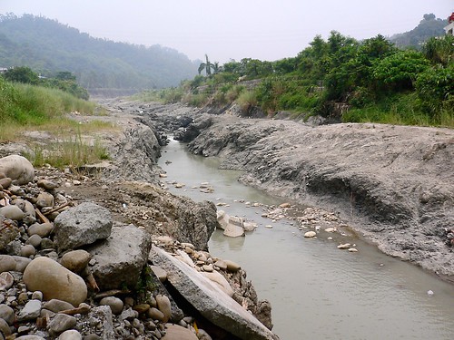
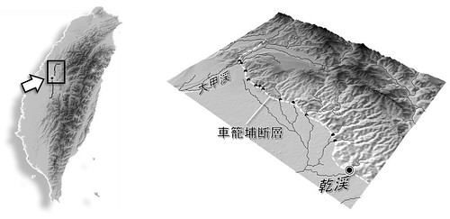
The Chi-Chi earthquake (M7.7), occurred on September 21, 1999, was associated with the activity of the Chelungpu Fault, along which surface ruptures continues for ca. 100 km with up to 10 m of vertical displacement. Waterfalls were formed in rivers flowing over the ruptures, and the most famous one having a height of 7 m was appeared in the Tachia River at the northernmost portion of the fault. The picture shows a fault-induced waterfall with 4-m height (at the center, slightly seen as white color) and a gorge of inner channel downstream of the waterfall in the Gan River in July 2005. This waterfall has receded for more than 200 m from the original location in 6 years after the earthquake, where rapid waterfall recession can be caused by abundant gravels transported from upstream areas with harder rocks, acting as abrasion material. We can also observe sidewall notches and downstream widening of the gorge, which suggest lateral erosion by the river following the waterfall recession. On the right side of the Gan River, facilities of formerly an elementary school, located just on the fault rupture and broken by the earthquake, are preserved and on exhibit as the Earthquake Museum.
(July 26, 2005, photo and text by Yuichi S. Hayakawa)
1999年9月21日,台湾中部でM7.7 の大地震が発生した。この際活動した車籠埔断層に沿って,地表には約100 km に渡る地震断層が生じ,その鉛直変位量は最大で10 m に及んだ。断層が河川を横切る地点は滝となり,とくに断層北部の大甲渓で高さ7 mの滝が形成されたことは多く報じられた。写真は,断層を跨ぐ河川の一つである乾渓において,2005年7月に撮影されたものである。細長く続く峡谷(inner channel)の奥に高さ約4 m の滝があり,この滝は地震発生から6年の間に元の断層の位置から200 m 以上も後退した。年間で数十メートルという後退速度は,岩盤侵食速度としては極端に大きい。これは,風化に対して脆弱な泥質の岩盤であることに加え,上流域から運搬されてくる硬質な砂礫が摩耗剤としてはたらき,侵食作用を促進させていることが一因であると考えられている。また,峡谷は下流ほど幅が広がり,その側壁にはノッチが形成されており,滝が後退したあとの側刻作用による谷の拡幅を示している。この乾渓右岸,断層の真上にあった学校は,その倒壊した建物や盛り上がった校庭が,地震教育園として保存・公開されている。
解説・写真:早川裕一
(表紙写真:地形29-1, 2008)

