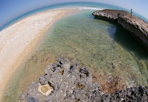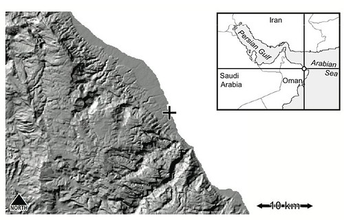

On June 6, 2007, a gigantic cyclone “Gonu” attacked eastern Oman, the northeastern Arabian Peninsula. The cyclone attack caused flash floods in wadi channels in the dry region, entraining vast amount of sand and gravel which instantaneously traveled throughout the channels. Coastal deposits of the sand and gravel spread around the wadi outlets (left side in the photo), and such numerous gravels associated with repeated storms might have been trapped into coral reefs to form gravel-rich carbonate rocks (or, calcareous conglomerate) shown in the bottom of the photo. The uplifted shore platform has a 3-m height at its edge with sharp and deep notches, and partially with fallen blocks induced by wave and gravity forces (right-top in the photo), which are rapidly broken toward small pieces. A shell midden site (BIMMA-1) at the Neolithic to Bronze Age is on the uplifted platform. The platform cliff, as well as the midden itself, has therefore suffered from erosion for thousands of years. Together with this uplifted shore platform, several coastal terraces with heights of 100 to 500 m are formed in the backyard, indicating the active tectonics in this region. Furthermore, the Oman ophiolite, the largest, most famous and complete ophiolite in the world, forms high mountains with altitudes of 2,000–3,000 m in the inland areas along the coast.
2007年6月6日,アラビア海(インド洋)で発生した大型サイクロン「ゴヌ」が北上を続け,オマーン湾とその周辺諸国を襲った。観測史上最大級のこのサイクロンは,オマーンの乾燥した大地に強風と豪雨をもたらし,普段は水の枯れたワディにも大量の水が流れ込んだ。激流は河床に溜まっていた砂礫を巻き込み,河口まで一気に運び出す。表紙写真の左側にみえる堆積物は,その際にワディから運び出された砂礫堆である。足元のサンゴを含む石灰岩にも礫が多く混入しており,この場所で大量の砂礫が繰り返し供給されていることを示している。右側と手前に張り出しているのは,高さ約3 m の隆起ベンチである。海側小崖の基部には鋭いノッチが発達し,写真右側の奥には波と重力とに耐えきれず崩落したブロックもみられる。この隆起ベンチ上には新石器後半から青銅器時代(およそ4-6千年前)の貝塚が分布し,少なくとも数千年間,ベンチの端は波の侵食を受けている。一度崩落したブロックは波の作用により急速に解体され,隆起ベンチ上には細かく打ち砕かれたブロックの破片が散在している。この写真の背後には数段の海岸段丘(標高100-500 m)が発達し,アラビア海沿岸域における地殻変動の歴史を物語っている。より内陸側には,かつてのテチス海の海洋地殻が標高2,000-3,000 m級の山脈を形成するほど持ちあげられ,世界で最も大規模かつ完全なオフィオライト,オマーンオフィオライトとして広く分布している。(2008年3月撮影)
(表紙写真:地形30 (2), 2009)