ラベル world の投稿を表示しています。 すべての投稿を表示

2020/05/21

Dashgil Mud Volcano at Gobustan, Azerbaijan / ダシュギル泥火山(アゼルバイジャン共和国)

Dashgil Mud Volcano at Gobustan, Azerbaijan / ダシュギル泥火山(アゼルバイジャン共和国)

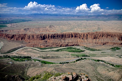
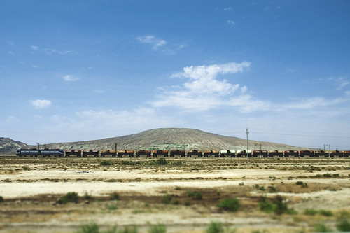
Numerous mud volcanoes are present in both offshore and onshore areas around Baku on the western coast of the Caspian Sea. Geomorphological studies have been carried out in the Dashgil Mud Volcano, located 50 km southwest of Baku, next to the Gobustan National Park that is a World Heritage with its cultural landscapes with prehistoric rock arts. The Dashgil has a 3-km diameter and 100-m summit elevation, and similar mud volcanoes are densely present in this region. "Dash (daş)" stands for rock or stone, while "gil" means clay. Normally, activities of these mud volcanoes are moderate with the continuous eruption of relatively cold materials including mud, water, and gas, but they can occasionally erupt massive gas to "explode" with flames hundreds of meters high.

カスピ海沿岸に位置するアゼルバイジャンの首都バクー周辺には、海底だけでなく陸上にも泥火山(でいかざん)が多数噴出している。地形学的な研究も行われているダシュギル泥火山は、バクーから南西に約50 km。近辺には、先史時代の岩絵などの文化的景観が世界遺産として登録されている、ゴブスタン国立保護区がある。ダシュギルは、直径3 km、標高100 m ほどの山であり、周辺にも同様の規模の泥火山が密に分布する。名称のダシュは石・岩、ギルは泥・粘土をあらわす。このような泥火山は、普段は穏やかに泥や水、ガスを噴出しているが、時折、何らかの要因で大量に放出されたガスが発火し、数百m もの高さの炎をともない「噴火」することがある。

(表紙写真:地形 38 (3), 2017)

2020/05/14

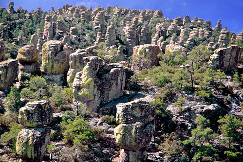
Hoodoos in Chiricahua National Monument, Arizona (USA) / チリカウワ国立公園の奇岩群(アメリカ合衆国)

Hoodoos in Chiricahua National Monument, Arizona (USA) / チリカウワ国立公園の奇岩群(アメリカ合衆国)

A large amount of rock monuments, composed of rhyolite welded ignimbrite by the Turkey Creek caldera eruption 27 million years ago, are present in this arid hilly land. Weathering and erosion along weak lineaments (joints) caused the formation of the tors, some of which are gravitationally displaced but keep superb balance before collapsing. Extensive wildfire (Horseshoe Two Fire) occurred in May-June 2011 to burn ca. 90,000 ha in this area.

乾燥したアリゾナの台地に多数の岩が林立する。約2700万年前のターキークリークのカルデラ噴火による流紋岩質の溶結火砕流堆積物からなる。弱線沿いに風化と侵食が進み、傾きつつも絶妙なバランスで崩落を免れている岩も多く見られる。2011年5〜6月には大規模な山火事でこの付近の9万haが焼けた。

(表紙写真:地形 37 (2), 2016)

2015/06/05

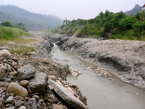
Bedrock erosion by waterfall recession after the 921 Chi-Chi earthquake, central Taiwan / 台湾中部,九二一地震で生じた滝の後退による岩盤侵食

Bedrock erosion by waterfall recession after the 921 Chi-Chi earthquake, central Taiwan / 台湾中部,九二一地震で生じた滝の後退による岩盤侵食

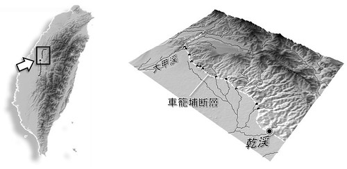
   The Chi-Chi earthquake (M7.7), occurred on September 21, 1999, was associated with the activity of the Chelungpu Fault, along which surface ruptures continues for ca. 100 km with up to 10 m of vertical displacement. Waterfalls were formed in rivers flowing over the ruptures, and the most famous one having a height of 7 m was appeared in the Tachia River at the northernmost portion of the fault. The picture shows a fault-induced waterfall with 4-m height (at the center, slightly seen as white color) and a gorge of inner channel downstream of the waterfall in the Gan River in July 2005. This waterfall has receded for more than 200 m from the original location in 6 years after the earthquake, where rapid waterfall recession can be caused by abundant gravels transported from upstream areas with harder rocks, acting as abrasion material. We can also observe sidewall notches and downstream widening of the gorge, which suggest lateral erosion by the river following the waterfall recession. On the right side of the Gan River, facilities of formerly an elementary school, located just on the fault rupture and broken by the earthquake, are preserved and on exhibit as the Earthquake Museum.
(July 26, 2005, photo and text by Yuichi S. Hayakawa)

 1999年9月21日,台湾中部でM7.7 の大地震が発生した。この際活動した車籠埔断層に沿って,地表には約100 km に渡る地震断層が生じ,その鉛直変位量は最大で10 m に及んだ。断層が河川を横切る地点は滝となり,とくに断層北部の大甲渓で高さ7 mの滝が形成されたことは多く報じられた。写真は,断層を跨ぐ河川の一つである乾渓において,2005年7月に撮影されたものである。細長く続く峡谷(inner channel)の奥に高さ約4 m の滝があり,この滝は地震発生から6年の間に元の断層の位置から200 m 以上も後退した。年間で数十メートルという後退速度は,岩盤侵食速度としては極端に大きい。これは,風化に対して脆弱な泥質の岩盤であることに加え,上流域から運搬されてくる硬質な砂礫が摩耗剤としてはたらき,侵食作用を促進させていることが一因であると考えられている。また,峡谷は下流ほど幅が広がり,その側壁にはノッチが形成されており,滝が後退したあとの側刻作用による谷の拡幅を示している。この乾渓右岸,断層の真上にあった学校は,その倒壊した建物や盛り上がった校庭が,地震教育園として保存・公開されている。
解説・写真:早川裕一

Untitled

(表紙写真:地形29-1, 2008)

2015/04/08

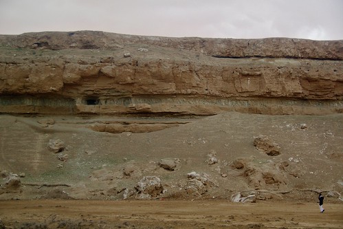
Cliff of fluvial terrace along the Euphrates River near Ar-Raqqa, Syrian Arab Republic / シリア共和国ラッカ近郊、ユーフラテス川右岸の河岸段丘崖

Cliff of fluvial terrace along the Euphrates River near Ar-Raqqa, Syrian Arab Republic / シリア共和国ラッカ近郊、ユーフラテス川右岸の河岸段丘崖

(March 7, 2010, photo by Yuichi S. Hayakawa)

 ビシュリの台地の北縁は、ユーフラテス川により切り込まれ比高60 m ほどの段丘崖をなす。崖は中新統の石灰岩・石膏岩と挟在するシルト質泥岩からなるが、1974年のタブカダム建設以降ユーフラテスの氾濫は抑えられ、現状、崖が侵食されることはほとんどない。

(表紙写真:地形32-3, 2011)

2015/04/07

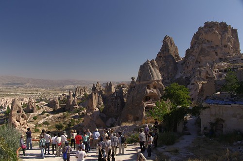
Erosional landforms of layered, non-welded ignimbrites in Cappadocia, Turkey / トルコ共和国、カッパドキアにおける火砕流堆積物の侵食地形

Erosional landforms of layered, non-welded ignimbrites in Cappadocia, Turkey / トルコ共和国、カッパドキアにおける火砕流堆積物の侵食地形 

 The rock mound on the right side is an inserberg named Uçhisar, in which many artificial caves are formed. Visited during the field trip of JGU-Ankara University joint meeting.
(September 16, 2010, photo by Yuichi S. Hayakawa)

 非溶結の火砕流堆積物が風化・侵食を受け、奇岩地形が広がっている。右側の岩山はウチヒサルと呼ばれる残丘地形。多くの洞穴が掘られている。JGU合同大会(アンカラ大学との共催)の巡検で訪れた。

(表紙写真:地形32-2, 2011)

2015/04/06

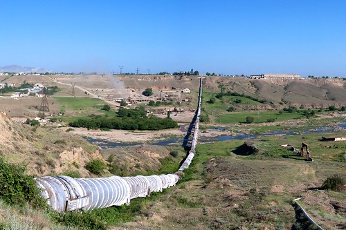
Deeply dissected valley in an alluvial fan of the Tovus River, western Azerbaijan / アゼルバイジャン共和国西部、トヴス川扇状地の開析谷

Deeply dissected valley in an alluvial fan of the Tovus River, western Azerbaijan / アゼルバイジャン共和国西部、トヴス川扇状地の開析谷

July 25, 2012, photo by Yuichi S. Hayakawa

 小コーカサス山脈から北流(写真左から右)するトヴス川は、本流であるクラ川に注ぐところで北向きの扇状地を形成する。その開析谷の比高は写真の地点で約60 m に及び、谷の内部には後氷期に形成された数段の段丘がみられる。現河床からは礫の採取も活発に行われ、対岸ではその工場からの煙が立ち上がっている。扇状地上を東西に流れる灌漑用水は、径2 m 超のパイプを通り、サイフォンとしてトヴスの深い谷を横断する。

(表紙写真:地形34-1, 2013)

2015/02/03

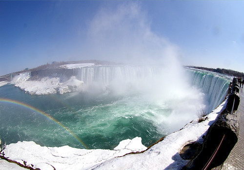
Erosion of Niagara Falls, Canada and the USA / ナイアガラフォールズの侵食

Erosion of Niagara Falls, Canada and the USA / ナイアガラフォールズの侵食

   Niagara Falls was formed at the Niagara Escarpment, 11 km downstream the present location of the waterfall, on ca. 12,500 years ago when the Niagara River drained from upstream Lake Erie across the cliff. The mean recession rate is ca. 1 m/y, while the long-term recession rate has varied due to changes of water discharge of the Niagara River. Water intake for power plant since a century ago caused decrease of the water discharge flowing over the waterfall, and the waterfall erosion has been stagnated, with its present recession rate on the order of centimeters a year. The embowed horseshoe shape of the waterfall can also be another factor stabilizing the waterfall against erosion.
   An erosion model on Niagara Falls has been proposed by G.K. Gilbert a century ago, suggesting the caprock structure of the waterfall face, in which erosion dominates on the lower shale layer (undercut by plunge-pool swirling flow). Although the model has long been regarded as representative one that explains waterfall erosion, such a caprock model cannot be applied for many other waterfalls that are buttressed, and severe erosion in the plunge pool is also doubtful because currents in the deep pool may not be so strong to cause entrainment of fallen brocks and bedrock erosion.
Photo and text by Yuichi S. Hayakawa

 ナイアガラフォールズは約12,500 年前,ローレンタイド氷床の後退にともない,エリー湖からオンタリオ湖へ向けて北流したナイアガラ川が,東西に走るナイアガラ・エスカープメントを横切る地点で形成された。以降,継続的な侵食により滝は現在の位置まで約11 kmを後退した。平均して年間約1 m 弱の後退速度となるが,過去の後退速度は一定ではなく,たとえば約1万年前からの5000年間は,エリー湖より上流の氷河湖からの流出経路が異なったため,1 kmしか後退が進まなかったことが貝化石の14C 年代(未較正)から推定されている。また,20 世紀には水力発電のための取水が始まり,観光用に日中の流量は確保されているものの,滝を通過する総流量は激減した。同時に滝の侵食も遅くなり,現在の後退速度は年間数 cm 程度であると言われている。また,ホースシューフォールズ(写真手前)は300 年前にはより直線的な平面形状を呈していたが,これが徐々に馬蹄形となることで応力分散により安定し,侵食が遅くなる一因となっているという説もある。
 20世紀初頭に提案されたG.K. Gilbert によるナイアガラフォールズの侵食モデルは,滝壺の渦流が滝面下部の頁岩の水平層を侵食し,キャップロックとなる上部のドロマイトが崩落する,というものであった。長い間これが滝の侵食の典型的なモデルとして広まっていたが,実際にはキャップロック構造をもたない滝は多く,滝一般においての事例としてはむしろ稀な方であろう。さらに滝壺底部に侵食をもたらすほどの渦流が生じるという説明は,ナイアガラフォールズにおいてさえ推測の域を出ておらず,滝の侵食プロセスに関して不明な点は未だに多い。


(表紙写真:地形 29-2, 2008)

2015/02/02

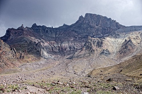
Disappearing glacier in Mt. Erciyes, central Turkey / トルコ共和国中部、エルジエス火山の山頂とその直下に現存する氷河

Disappearing glacier in Mt. Erciyes, central Turkey / トルコ共和国中部、エルジエス火山の山頂とその直下に現存する氷河

Disappearing glacier in Mt. Erciyes, central Turkey.
(August 2014, photo by Yuichi S. Hayakawa)

 トルコ中部、カイセリ近郊に位置するエルジエス山(山頂標高3,916 m)には氷河や岩石氷河が現存する。しかし1900年代初頭に初めて報告されてから氷河は後退を続けており、現在は山頂直下の崖下にわずかに残るのみとなる(写真中央右)。氷河より下流にはモレーンやアウトウォッシュプレーンなど氷河性の堆積物も分布している。(2014.08)

(表紙写真:地形 35-4, 2014)

2015/02/01

The Naryn River and mountains in Naryn, northern Tien Shan (Kyrgiz) / キルギス共和国中部,ナリン高地

Mountians and the Naryn River around Naryn, the northern Tien Shan (Kyrgiz) / キルギス共和国中部、ナリン周辺の山地と河川(2014.07)

The Naryn River and mountains in Naryn, northern Tien Shan (Kyrgiz)
(July 2014, photo by Yuichi S. Hayakawa)

 天山山脈の北部,ナリンから北方を望む.写真中央を西に流れるナリン川は,上流の氷河からの濁った水を湛え,その下流ではシルダリヤ川と名を変えアラル海に注ぐ.谷中に形成された段丘面上には,旧石器時代に遡る遺跡が分布している.(2014.07)

(表紙写真:地形36-1, 2015)

2014/05/05

Low-relief erosional surfaces and Erciyes Dağı (Mt. Erciyes) volcano in Anatolian highland / アナトリア高原の小起伏面とエルジエス火山(トルコ共和国カイセリ県)

Low-relief erosional surfaces and Erciyes Dağı (Mt. Erciyes) volcano in Anatolian highland / アナトリア高原の小起伏面とエルジエス火山(トルコ共和国カイセリ県)

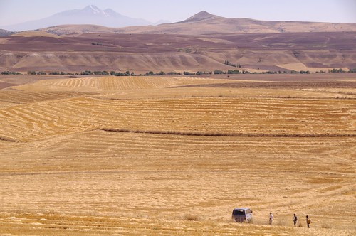
   Low-relief erosional surfaces are widely present in central Anatolian highland, where mountains or hills surrounded by gentle slopes are covered with crop fields to their summits. Slopes on these "low-relief" surfaces are generally gentle and geomorphic processes therein seems relatively slow, but many active geomorphic features are actually found: for instance, current small rivers incises for several meters in depth into a wide Holocene floodplain (shown in the center of the photo, a river runs along the trees from left to right), and steep slopes beyond the river have thin soil layer and surface materials are actively transported during heavy rainfall and in snowmelt season. Although the overall form of the low-relief surfaces can be peneplain or a relict landform of ancient long-term erosion, present geomorphic process are not so inactive in the region.
   Many active faults run through these low-relief surfaces surrounding the Anatolian highland. A pull-apart basin, divided by normal or slip faults (a part of the East Anatolian fault zone), is located beyond the hill ridge in the upper portion of the photo, where volcanic activities have occurred since several million years ago.
   Mt. Erciyes (3,917 m), shown in the upper left of the photo, is the highest volcano in central Anatolia. The mountain provides a place of skiing in winter, and snow around the summit is observable year-round. A glacier is present just below the summit on the north-facing slope (photo), which have severely retreated and is shortly disappearing. The photo shows an amazing scenery which contrast strong sunlight in the close view and cold ice in the distant view.
(Photograph and text by Yuichi S. Hayakawa, Aug. 2009)

 アナトリア高原中央部は広く侵食小起伏面からなる。乾燥して高木の乏しいなだらかな山には,その頂上にまで畑が広く覆っている。山や丘のてっぺんには,テペと呼ばれる遺丘が多く乗り,写真もそのうちの一つから撮影したものだ。
 「小起伏」面とはいっても,しかし,それなりに起伏はある。道には坂やコーナーが延々と続き,大河川は深い谷を刻む。写真中央遠方の緑の木々に沿っては小川が流れており,数百m幅の広い沖積層を谷底に溜める。その向こうの急斜面は草もまばらで土壌も浅く,豪雨や雪解け時には土砂移動が生じている。小起伏面の概形は,かつての河川等による侵食を反映した残存地形(いわゆる準平原)であると言われる。しかし,現在でもさまざまな地形変化プロセスが,速度は遅くとも,着実に進行していることも事実である。
 こうした小起伏面を切り裂く断層帯が,アナトリア小プレートを取り囲むように分布している。写真上,稜線の向こう側には,南西―北東に走る正・横ずれ断層帯に挟まれた盆地が広がる。この地域はテクトニクス的な拡大場にあり,火山活動が数百万年以上も前から続いている。
 左に遠望されるのがエルジエス火山(標高3,917 m)。中央アナトリア地方の最高峰である。冬にはスキーリゾートとして賑わい,夏でも山頂付近には雪が残る。写真手前が北向き斜面であり,山頂直下には氷河や岩石氷河も存在する。ただ,この氷河も縮小傾向にあり,一昨年と昨年は史上初めて麓からの遠景で夏に雪が見えなくなったという。なお,奇岩地形で有名なカッパドキアはこの火山の西に広がり,これはエルジエスより古い時代の火山活動にともなう火砕流堆積物の台地が開析されてできている。
(2009年8月撮影)


Low-relief erosional surfaces and Erciyes Dağı (Mt. Erciyes) volcano in Anatolian highland / アナトリア高原の小起伏面とエルジエス火山(トルコ共和国カイセリ県)
(表紙写真:地形30 (4), 2009)

2013/01/30

Uplifted shore platform and cyclone-derived debris flow deposits, northeastern coast of the Arabian Peninsula, Sultanate of Oman / アラビア半島北東海岸(オマーン国)の隆起ベンチとサイクロンによる砂礫堆積物

Uplifted shore platform and cyclone-derived debris flow deposits, northeastern coast of the Arabian Peninsula, Sultanate of Oman / アラビア半島北東海岸(オマーン国)の隆起ベンチとサイクロンによる砂礫堆積物
Location: Uplifted shore platform and cyclone-derived debris flow deposits, northeastern coast of the Arabian Peninsula, Sultanate of Oman / アラビア半島北東海岸(オマーン国)の隆起ベンチとサイクロンによる砂礫堆積物

   On June 6, 2007, a gigantic cyclone “Gonu” attacked eastern Oman, the northeastern Arabian Peninsula. The cyclone attack caused flash floods in wadi channels in the dry region, entraining vast amount of sand and gravel which instantaneously traveled throughout the channels. Coastal deposits of the sand and gravel spread around the wadi outlets (left side in the photo), and such numerous gravels associated with repeated storms might have been trapped into coral reefs to form gravel-rich carbonate rocks (or, calcareous conglomerate) shown in the bottom of the photo. The uplifted shore platform has a 3-m height at its edge with sharp and deep notches, and partially with fallen blocks induced by wave and gravity forces (right-top in the photo), which are rapidly broken toward small pieces. A shell midden site (BIMMA-1) at the Neolithic to Bronze Age is on the uplifted platform. The platform cliff, as well as the midden itself, has therefore suffered from erosion for thousands of years. Together with this uplifted shore platform, several coastal terraces with heights of 100 to 500 m are formed in the backyard, indicating the active tectonics in this region. Furthermore, the Oman ophiolite, the largest, most famous and complete ophiolite in the world, forms high mountains with altitudes of 2,000–3,000 m in the inland areas along the coast.

 2007年6月6日,アラビア海(インド洋)で発生した大型サイクロン「ゴヌ」が北上を続け,オマーン湾とその周辺諸国を襲った。観測史上最大級のこのサイクロンは,オマーンの乾燥した大地に強風と豪雨をもたらし,普段は水の枯れたワディにも大量の水が流れ込んだ。激流は河床に溜まっていた砂礫を巻き込み,河口まで一気に運び出す。表紙写真の左側にみえる堆積物は,その際にワディから運び出された砂礫堆である。足元のサンゴを含む石灰岩にも礫が多く混入しており,この場所で大量の砂礫が繰り返し供給されていることを示している。右側と手前に張り出しているのは,高さ約3 m の隆起ベンチである。海側小崖の基部には鋭いノッチが発達し,写真右側の奥には波と重力とに耐えきれず崩落したブロックもみられる。この隆起ベンチ上には新石器後半から青銅器時代(およそ4-6千年前)の貝塚が分布し,少なくとも数千年間,ベンチの端は波の侵食を受けている。一度崩落したブロックは波の作用により急速に解体され,隆起ベンチ上には細かく打ち砕かれたブロックの破片が散在している。この写真の背後には数段の海岸段丘(標高100-500 m)が発達し,アラビア海沿岸域における地殻変動の歴史を物語っている。より内陸側には,かつてのテチス海の海洋地殻が標高2,000-3,000 m級の山脈を形成するほど持ちあげられ,世界で最も大規模かつ完全なオフィオライト,オマーンオフィオライトとして広く分布している。(2008年3月撮影)

(表紙写真:地形30 (2), 2009)

2010/09/08

上から下まで - alluvial cone near Bergün, the Swiss Alps


alluvial cone near Bergün, the Swiss Alps

水や、石ころなど、地表の物質というものは、放っておけば高いところから低いところへと落ちてゆく。

スイスの山はおおむね、大昔に海底だったところが隆起してできたものであるが、ただ盛り上がったというだけではない。
地盤が隆起すれば、常にそれに逆らい、山を低くしようとする力もはたらく。これを侵食という。
山の頂上はそれ故、高くなったり低くなったりを繰り返している。
そして崩れた岩盤は、石ころとなり、砂となり、流され、やがて定置する。

山の上から削られ流されてきた石や泥の塊が、谷底で積み重なっている。
山の地形は動的に変化しているのだ。

2009/07/22

砂の島 - Fraser Island - Queensland, Australia

大陸の岩盤は長年の侵食により、やがて砂となり川で海へと運ばれる。
海へ吐き出された砂は、今度は波によって海岸沿いにその居場所を振り分けられる。

そうして運ばれた砂が溜まりに溜まって、巨大な島となったのが、オーストラリア東岸のフレーザー島だ。
砂の島としては、世界でいちばん大きい。

通常、砂嘴(さし)と言えば、河口の辺りに数百メートル、あるいはせいぜい数キロメートル程度に渡って延びた砂の堆積する場所のことを言う。
それに比べると、この砂島の規模は100kmを超え、とてつもなく大きい。飛行機からでも、その全体像は望めないだろう。

どれだけ大量の砂が、どれだけの時間をかけて溜まり、この島を形成したのだろうか。

ちなみにこの島はグレート・サンディ国立公園として世界遺産に登録されている。
このネーミングは、日本語訳で「壮大な砂の公園」、とでもなるだろうか。
なかなかわかりやすくて良いかもしれない。

2009/07/18

波は岩を削る。 - Great Ocean Road - Victoria, Australia

オーストラリア南岸に、グレート・オーシャン・ロードと呼ばれる海沿いの道がある。
かつて第一次世界大戦の帰還兵のための公共事業として造られたというが、今はヴィクトリア州でも有数の観光スポットとなっている。

海沿いには、所々に砂のビーチを挟みつつ、岩の崖が延々と続く。
海に面した崖は海食崖と呼ばれ、波の当たる部分、つまり海水面の高さ付近が凹んでいることがよくある。
このノッチと呼ばれる凹みは、長い間その部分に波が繰り返しぶつかり、徐々に岩が削られてきたことの結果だ。

崖の岩は、石灰岩(サンゴ礁起源と思われる)や砂岩、泥岩などがほぼ水平に、交互に積み重なってできている。
コンクリートのようにガチガチでもなく、比較的削られやすい。

この日は波も穏やかだったが、サーフィンのメッカともいわれるこの場所では、それなりに強い波がそこそこの頻度でやってくるのだろう。
すると、崖が削られる速さもそれほど遅くもないのかもしれない。
たとえば100年後には、海岸の岩が何メートルか削られ、海岸線が変わっているのかも。

地形の変化は、それだけ急速だったり、もっと緩やかだったり、予測は難しいものなのだが。