ラベル asia の投稿を表示しています。 すべての投稿を表示

2020/05/21

Dashgil Mud Volcano at Gobustan, Azerbaijan / ダシュギル泥火山(アゼルバイジャン共和国)

Dashgil Mud Volcano at Gobustan, Azerbaijan / ダシュギル泥火山(アゼルバイジャン共和国)

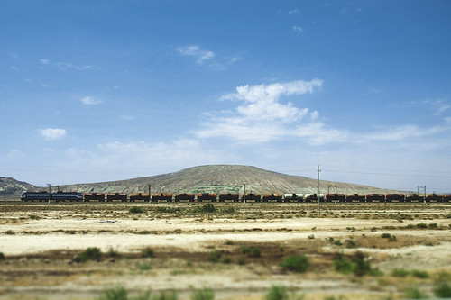
Numerous mud volcanoes are present in both offshore and onshore areas around Baku on the western coast of the Caspian Sea. Geomorphological studies have been carried out in the Dashgil Mud Volcano, located 50 km southwest of Baku, next to the Gobustan National Park that is a World Heritage with its cultural landscapes with prehistoric rock arts. The Dashgil has a 3-km diameter and 100-m summit elevation, and similar mud volcanoes are densely present in this region. "Dash (daş)" stands for rock or stone, while "gil" means clay. Normally, activities of these mud volcanoes are moderate with the continuous eruption of relatively cold materials including mud, water, and gas, but they can occasionally erupt massive gas to "explode" with flames hundreds of meters high.

カスピ海沿岸に位置するアゼルバイジャンの首都バクー周辺には、海底だけでなく陸上にも泥火山(でいかざん)が多数噴出している。地形学的な研究も行われているダシュギル泥火山は、バクーから南西に約50 km。近辺には、先史時代の岩絵などの文化的景観が世界遺産として登録されている、ゴブスタン国立保護区がある。ダシュギルは、直径3 km、標高100 m ほどの山であり、周辺にも同様の規模の泥火山が密に分布する。名称のダシュは石・岩、ギルは泥・粘土をあらわす。このような泥火山は、普段は穏やかに泥や水、ガスを噴出しているが、時折、何らかの要因で大量に放出されたガスが発火し、数百m もの高さの炎をともない「噴火」することがある。

(表紙写真:地形 38 (3), 2017)

2015/06/05

Bedrock erosion by waterfall recession after the 921 Chi-Chi earthquake, central Taiwan / 台湾中部,九二一地震で生じた滝の後退による岩盤侵食

Bedrock erosion by waterfall recession after the 921 Chi-Chi earthquake, central Taiwan / 台湾中部,九二一地震で生じた滝の後退による岩盤侵食

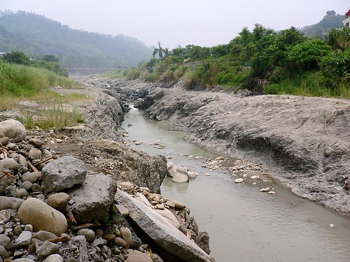
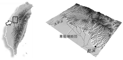
   The Chi-Chi earthquake (M7.7), occurred on September 21, 1999, was associated with the activity of the Chelungpu Fault, along which surface ruptures continues for ca. 100 km with up to 10 m of vertical displacement. Waterfalls were formed in rivers flowing over the ruptures, and the most famous one having a height of 7 m was appeared in the Tachia River at the northernmost portion of the fault. The picture shows a fault-induced waterfall with 4-m height (at the center, slightly seen as white color) and a gorge of inner channel downstream of the waterfall in the Gan River in July 2005. This waterfall has receded for more than 200 m from the original location in 6 years after the earthquake, where rapid waterfall recession can be caused by abundant gravels transported from upstream areas with harder rocks, acting as abrasion material. We can also observe sidewall notches and downstream widening of the gorge, which suggest lateral erosion by the river following the waterfall recession. On the right side of the Gan River, facilities of formerly an elementary school, located just on the fault rupture and broken by the earthquake, are preserved and on exhibit as the Earthquake Museum.
(July 26, 2005, photo and text by Yuichi S. Hayakawa)

 1999年9月21日,台湾中部でM7.7 の大地震が発生した。この際活動した車籠埔断層に沿って,地表には約100 km に渡る地震断層が生じ,その鉛直変位量は最大で10 m に及んだ。断層が河川を横切る地点は滝となり,とくに断層北部の大甲渓で高さ7 mの滝が形成されたことは多く報じられた。写真は,断層を跨ぐ河川の一つである乾渓において,2005年7月に撮影されたものである。細長く続く峡谷(inner channel)の奥に高さ約4 m の滝があり,この滝は地震発生から6年の間に元の断層の位置から200 m 以上も後退した。年間で数十メートルという後退速度は,岩盤侵食速度としては極端に大きい。これは,風化に対して脆弱な泥質の岩盤であることに加え,上流域から運搬されてくる硬質な砂礫が摩耗剤としてはたらき,侵食作用を促進させていることが一因であると考えられている。また,峡谷は下流ほど幅が広がり,その側壁にはノッチが形成されており,滝が後退したあとの側刻作用による谷の拡幅を示している。この乾渓右岸,断層の真上にあった学校は,その倒壊した建物や盛り上がった校庭が,地震教育園として保存・公開されている。
解説・写真:早川裕一

Untitled

(表紙写真:地形29-1, 2008)

2015/04/08

Cliff of fluvial terrace along the Euphrates River near Ar-Raqqa, Syrian Arab Republic / シリア共和国ラッカ近郊、ユーフラテス川右岸の河岸段丘崖

Cliff of fluvial terrace along the Euphrates River near Ar-Raqqa, Syrian Arab Republic / シリア共和国ラッカ近郊、ユーフラテス川右岸の河岸段丘崖

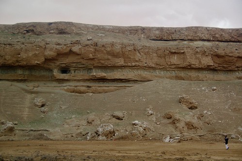
(March 7, 2010, photo by Yuichi S. Hayakawa)

 ビシュリの台地の北縁は、ユーフラテス川により切り込まれ比高60 m ほどの段丘崖をなす。崖は中新統の石灰岩・石膏岩と挟在するシルト質泥岩からなるが、1974年のタブカダム建設以降ユーフラテスの氾濫は抑えられ、現状、崖が侵食されることはほとんどない。

(表紙写真:地形32-3, 2011)

2015/04/07

Erosional landforms of layered, non-welded ignimbrites in Cappadocia, Turkey / トルコ共和国、カッパドキアにおける火砕流堆積物の侵食地形

Erosional landforms of layered, non-welded ignimbrites in Cappadocia, Turkey / トルコ共和国、カッパドキアにおける火砕流堆積物の侵食地形 

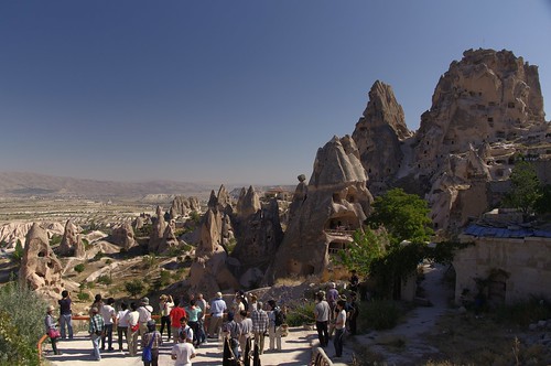
 The rock mound on the right side is an inserberg named Uçhisar, in which many artificial caves are formed. Visited during the field trip of JGU-Ankara University joint meeting.
(September 16, 2010, photo by Yuichi S. Hayakawa)

 非溶結の火砕流堆積物が風化・侵食を受け、奇岩地形が広がっている。右側の岩山はウチヒサルと呼ばれる残丘地形。多くの洞穴が掘られている。JGU合同大会(アンカラ大学との共催)の巡検で訪れた。

(表紙写真:地形32-2, 2011)

2015/04/06

Deeply dissected valley in an alluvial fan of the Tovus River, western Azerbaijan / アゼルバイジャン共和国西部、トヴス川扇状地の開析谷

Deeply dissected valley in an alluvial fan of the Tovus River, western Azerbaijan / アゼルバイジャン共和国西部、トヴス川扇状地の開析谷

July 25, 2012, photo by Yuichi S. Hayakawa

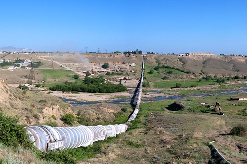
 小コーカサス山脈から北流(写真左から右)するトヴス川は、本流であるクラ川に注ぐところで北向きの扇状地を形成する。その開析谷の比高は写真の地点で約60 m に及び、谷の内部には後氷期に形成された数段の段丘がみられる。現河床からは礫の採取も活発に行われ、対岸ではその工場からの煙が立ち上がっている。扇状地上を東西に流れる灌漑用水は、径2 m 超のパイプを通り、サイフォンとしてトヴスの深い谷を横断する。

(表紙写真:地形34-1, 2013)

2015/02/01

The Naryn River and mountains in Naryn, northern Tien Shan (Kyrgiz) / キルギス共和国中部,ナリン高地

Mountians and the Naryn River around Naryn, the northern Tien Shan (Kyrgiz) / キルギス共和国中部、ナリン周辺の山地と河川(2014.07)

The Naryn River and mountains in Naryn, northern Tien Shan (Kyrgiz)
(July 2014, photo by Yuichi S. Hayakawa)

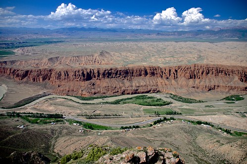
 天山山脈の北部,ナリンから北方を望む.写真中央を西に流れるナリン川は,上流の氷河からの濁った水を湛え,その下流ではシルダリヤ川と名を変えアラル海に注ぐ.谷中に形成された段丘面上には,旧石器時代に遡る遺跡が分布している.(2014.07)

(表紙写真:地形36-1, 2015)

2014/05/08

北東アフガニスタンの斜面崩壊:報道写真からの3Dデータ作成 / 3D data construction of the landslide in northeastern Afghanistan from reported photographs

2014年5月2日に発生した北東アフガニスタンでの大規模斜面崩壊(地すべり)について、報道されている写真から3Dデータ化を試みた。
I tried to construct three-dimensional data from photographs taken by reporters.

使用したのは、以下のようなサイトでも公開されている、様々なソースの写真。最終的に5つの空中写真を利用した。 (はじめは先に公開されていた地上写真からも試みたが、視点が異なり過ぎてうまくマッチングしなかった。)
The photographs from various sources shown in the websites below were used for the 3D reconstruction. Five aerial photographs were successful to be used.
boston.com  The Atlantic

PhotoScan(R) を使用し、基準点座標はGoogle Earth から参照しながら、SfM(モーションからの構造解析)による3Dモデルを作成。
Structure-from-Motion (SfM) was performed to create a 3D model from the photographs using PhotoScan(R) software. Coordinates of ground control points (GCP) were obtained by referring to the points in satellite images on Google Earth.


ただしモデル作成後の基準点座標には100 m 近いの誤差も含まれる(Total error = 53.8 m)。
The GCP errors are typically 53.8 m but some are nearly 100 m.

KML(KMZ)ファイルにエクスポートし、Google Earth 上で表示させると、崩壊発生前後の変化がよく読み取れる。
Exporting to KML (KMZ) file, the scenery before and after the landslide occurrence can be seen on Google Earth. [ source KML ]